Live: Bay of Bengal depression (IMD status at 11:30 pm IST, 24 October 2026)
This system has not yet become a cyclonic storm, so it has no name yet. IMD names a storm only at that stage, which it forecasts for the morning of 26 October. This page will be renamed when that happens.
Page last refreshed: 8:15 am IST, 25 October 2026, from IMD’s 11:30 pm IST (1800 UTC) bulletin of 24 October, the latest I have; a bulletin issued after that may not be on this page yet. It is refreshed every 6 hours (about 6 am, 12 noon, 6 pm and midnight IST) until landfall.
-
What exists now: the depression over the east-central and adjoining southeast Bay of Bengal moved southeastwards at 8 km/h in the six hours to 11:30 pm IST on 24 October. At that time it lay centred near 15.5°N, 91.0°E: about 470 km north-northwest of Sri Vijaya Puram (Andaman Islands), 860 km east-southeast of Visakhapatnam, 950 km east-southeast of Kakinada, 1,060 km east of Machilipatnam and 1,130 km east of Bapatla. Six hours earlier (5:30 pm IST) it was near 15.8°N, 90.7°E.
-
IMD forecast, step by step: it is very likely to move nearly southwards, become a deep depression and then gradually recurve west-northwestwards on 25 October. It should become a cyclonic storm by the morning of 26 October, a severe cyclonic storm over the west-central Bay around the morning of 27 October, and then a very severe cyclonic storm moving northwest to reach the west-central Bay near the Andhra Pradesh coast around the morning of 28 October. IMD’s map shows these stages at 11:30 am and 11:30 pm IST on each day.
-
Landfall (IMD forecast): it is very likely to cross the Andhra Pradesh and Yanam coasts between Bapatla and Visakhapatnam as a very severe cyclonic storm by the forenoon of 28 October, with maximum sustained winds of 115 to 125 km/h gusting to 140 km/h. The forecast has not changed since the 5:30 pm bulletin. Over three to four days it can still shift; IMD’s cone of uncertainty is wide.
-
Sea (IMD impact guide): wind of 52 to 61 km/h means very rough seas, 62 to 91 km/h high to very high seas, 92 to 117 km/h very high seas, and 118 km/h or more phenomenal seas. IMD’s action for every one of these is a total suspension of fishing operations in the affected area. Fishermen should not go to sea, and those at sea should return.
-
Rain (IMD national briefing, 24 October): isolated extremely heavy rain is likely over coastal Andhra Pradesh on 27 and 28 October, and over Odisha and Telangana on 28 October; isolated heavy to very heavy rain is also likely over Odisha on 27 and 29 October. IMD’s colour-coded warning maps show the highest warning level (red) along the coast of Andhra Pradesh and south Odisha on 28 October, with orange around it, and lower alerts on 29 and 30 October. IMD has also asked fishing, shipping, port and offshore operators to prepare.
-
A second system: IMD’s briefing also notes a low pressure area over the southeast Arabian Sea and adjoining Lakshadweep, with isolated extremely heavy rain likely over Tamil Nadu, Puducherry and Karaikal on 24 and 25 October, and over Kerala and Mahe on 25 and 26 October. It is separate from the Bay of Bengal system.
-
District alerts (IMD, as reported on 24 October): for Odisha, red alert on 27 October for Puri, Ganjam and Gajapati, and on 28 October for Ganjam, Gajapati, Rayagada, Koraput and Malkangiri. Orange alerts on 27 and 28 October cover many other coastal and interior districts, among them Balasore, Bhadrak, Kendrapara, Jagatsinghpur, Cuttack, Khordha, Nayagarh, Kandhamal and, on 28 October, Puri. In Andhra Pradesh, intense rain is forecast for parts of Anakapalli, Alluri Sitharama Raju, Kakinada, East Godavari, West Godavari and Konaseema, very heavy rain for Srikakulam and Krishna, and the highest risk is on 27 and 28 October. Alerts can change with each bulletin; check IMD and your district administration.
-
State response (Odisha government, reported 24 October): the Chief Minister has reviewed preparedness. Districts of major concern are Ganjam, Gajapati, Rayagada, Koraput and Malkangiri. Schools and Anganwadi centres in the affected districts stay closed on 28 and 29 October (collectors may extend this). About 60 ODRAF teams, 17 NDRF teams and 225 fire service teams are deployed or on alert, fishermen have been told not to go to sea, and people in vulnerable areas, with priority for patients, senior citizens and pregnant women, are to be moved to safer places.
Track map
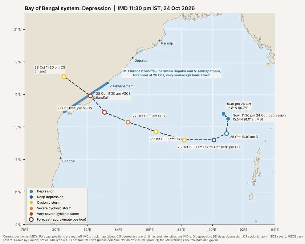
Map drawn by Claude (source data: India Meteorological Department) from IMD’s 11:30 pm IST (1800 UTC) bulletin and track map of 24 October 2026. The two observed positions (15.8°N, 90.7°E at 5:30 pm and 15.5°N, 91.0°E at 11:30 pm) are IMD’s exact figures; the forecast positions are read off IMD’s track map and are accurate to about half a degree, so they are drawn as open circles. The times and intensities at each step are IMD’s. Colours show the stage: blue depression, dark blue deep depression, yellow cyclonic storm, orange severe cyclonic storm, red very severe cyclonic storm. This is not an official IMD product. Land: Natural Earth, public domain.
IMD’s official track maps
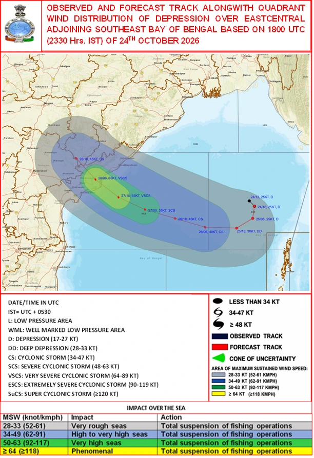
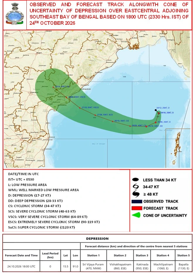
Both maps are IMD’s own products, reproduced here as published by IMD on 24 October 2026, and are not redrawn. Times on IMD’s maps are in UTC (IST is UTC plus 5:30). The newest IMD maps may be more recent than these; check mausam.imd.gov.in.
Satellite view
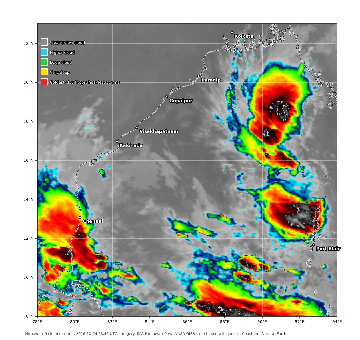
Himawari-9 clean infrared view of the Bay of Bengal at 23:46 UTC on 24 October (5:16 am IST, 25 October 2026), with coastline, grid and city names added. Colours show how cold, and so how high, the cloud tops are: grey is clear sky or low cloud, and blue, green, yellow and red mark ever deeper storm cloud. Red and black are the coldest tops, the heaviest storm clouds. Two large masses of deep cloud lie over the east-central Bay, one roughly 16.5 to 20°N and 89.5 to 92°E and another near the Andaman Islands, 12.5 to 14.5°N and 90 to 93°E. The system’s centre cannot be read from a single view; follow IMD for its position. Imagery: JMA Himawari-9 via NASA GIBS / Worldview (NASA imagery is free to use with credit); coastline: Natural Earth.
If you live on the Andhra Pradesh coast (especially between Bapatla and Visakhapatnam, including the Godavari and Konaseema districts) or on the south Odisha coast, this is the time to do the “Cyclone alert” checklist in Part 10 of the full guide, and to follow only IMD and your district administration for the landfall forecast. Model guesses circulating on social media are not warnings.
This page shows IMD’s forecast at the time stated above. For the latest position and warnings, follow IMD (mausam.imd.gov.in) and your district administration. For the science behind the terms used here (depression, deep depression, cyclonic storm, landfall, storm surge), read From Low Pressure to Super Cyclone: India’s Cyclones Explained.
Sources: IMD’s posts of the 5:30 pm IST (1200 UTC) and 11:30 pm IST (1800 UTC) bulletins and track maps for 24 October 2026, shared by the site owner; ETV Bharat and ANI reports of the IMD bulletin of 24 October 2026; Deccan Chronicle (IMD Director General’s statement, 23 October 2026); Sambad English (Odisha government measures, 24 October 2026); Goodreturns (IMD district alerts, 24 October 2026); IMD national weather briefing video of 24 October 2026; IMD (mausam.imd.gov.in).